WEEKLY WEATHER FORECAST
Monday 03/03/2025
By Monday, High Pressure will be moving off to our East. This will cause the winds to shift to out of the South which will cause warmer, more humid air to move into our area. Because of this, we will see temperatures get up into the 40’s but cloud cover will increase.
Tuesday 03/04/2025
On Tuesday, a strong Low Pressure system will be approaching the Ohio Valley from the West. As the Low approaches expect cloud cover to continue to increase and it will start to get windy. Temperatures will continue to rise with many of us seeing highs near 60 degrees! There may be some scattered rain showers as the humidity level will be very high. By Tuesday evening the Cold Front associated with the Low will move into western Ohio. Severe Thunderstorms and Tornadoes may be possible Tuesday evening, but once the Sun goes down the chances of severe weather will decrease. Rain and thunderstorms will move across the Ohio Valley Tuesday night.
Wednesday 03/05/2025
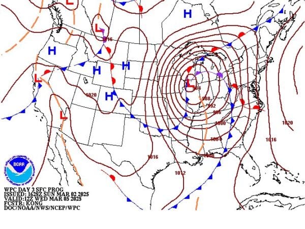
Thunderstorms could become severe again Wednesday morning once the Sun comes up. This means that TORNADOES could even be possible, especially Wednesday morning. Even if there are not TORNADOES, it will be VERY WINDY on Wednesday! Expect temperatures to once again be in the upper 50’s or low 60’s! Chances of rain will continue through the day. By Wednesday evening Arctic air will plunge southward causing lingering rain showers to change over to SNOW SHOWERS. Some accumulation may be possible by Thursday morning as temperatures are expected to drop into the 20’s Wednesday night!
Thursday 03/06/2025
Expect Lake Effect Snow Showers and Flurries to continue, especially Thursday morning. Temperatures will be much colder with afternoon highs only in the mid 30’s. It will also continue to be fairly windy.
Friday 03/07/2025
Weak High Pressure to our South will put an end the Snow Showers, but it will remain very cloudy. Temperatures will moderate with highs reaching into the 40’s.
Saturday 03/08/2025
A weak Low Pressure system will cross over the Ohio Valley. Depending on the track of this system it could bring rain, snow, or a mix of both to our area.
The map is for Wednesday morning and it shows a strong Low Pressure system crossing over the Ohio Valley.
For more details regarding the weather of the Ohio Valley, join my Pro-Site! http://www.patreon.com/OhioValleyWeather

