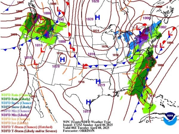
Weekly Weather Forecast
Sunday 04/06/2025
The Cold Front that has brought us rain for several days is finally slowly moving off to our East. But, rain showers will continue through the day today. Expect temperatures to be much cooler than normal with highs only in the upper 30’s or low 40’s. After the sun goes down temperatures will fall and it will be possible to see SNOW mixing in with the rain, especially for locations north of I-70.
Monday 04/07/2025
Expect a break in the precipitation Monday morning. Breaks in the clouds may allow temperatures to warm into the low 50’s by afternoon. But, later in the day, a weak Low Pressure system will drop down from Canada and move across the Great Lakes. Because of this, rain will be possible by late Monday afternoon. And, by Monday evening we could see the rain change over to SNOW SHOWERS which could continue through Tuesday morning.
Tuesday 04/08/2025
Expect extremely cold temperatures in the morning with lows in the mid 20’s with SNOW FLURRIES. With temperatures in the 20’s it will be possible for the snow to stick to the roads creating slick spots, especially on bridges which can quickly freeze. By afternoon temperatures will rise into the upper 30’s or low 40’s. Tuesday night it will be very cold with temperatures only in the low 20’s.
Wednesday 04/09/2025
Another Low Pressure system will be approaching the Ohio Valley from the West. As the system approaches SNOW SHOWERS may be possible, especially for locations North of I-70. By late afternoon the precipitation will change over to all RAIN. Expect afternoon temperatures to be in the upper 40’s or low 50’s. Rain, possibly with Thunderstorms will continue overnight through Thursday morning.
Thursday 04/10/2025
Rain showers will continue in the morning. Expect afternoon highs near 50 degrees. Once the sun goes down temperatures will drop allowing the rain to once again, possibly, change over to SNOW, especially for locations north of I-70.
Friday 04/11/2025
Snow Showers could continue in the morning, especially for locations north of I-70. But, with temperatures in the mid 30’s accumulation is not likely. As the day continues chances of precipitation will decrease. Expect highs in the upper 40’s.
Saturday 04/12/2025
A strong Low Pressure system is expected to form near the East Coast and become a Nor’easter. This could result in significant SNOWFALL for locations in West Virginia and Pennsylvania. As of right now, it looks like this will mostly miss Ohio, but that could change.
Sunday 04/13/2025
The Snow from Saturday could continue into Sunday morning. Some of the models are suggesting that by Sunday the Snow could move into eastern Ohio, but with temperatures on the warm side, accumulation is not likely. Accumulation may be possible in the mountains of Pennsylvania, West Virginia, and western Maryland.
For more details join my Pro-Site! http://www.patreon.com/OhioValleyWeather


