Weekly Forecast:
Monday 02/24/2025
High Pressure is moving off to our East. This is allowing warmer and more humid air to move into our area. Expect a mostly cloudy day with highs in the low 50’s.
Tuesday 02/25/2025
A weak Low Pressure system will pass over us bringing chances of Rain showers in the morning. The Rain could mix with Snow over higher elevations. By afternoon the Rain and Snow will move out of our area. Expect highs to be a little cooler than Monday, but still near 50 degrees.
Wednesday 02/26/2025
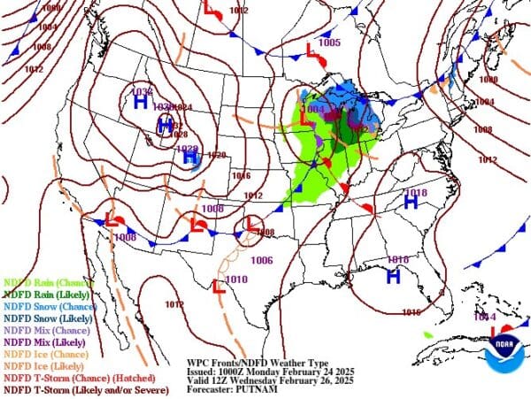
On Wednesday a fairly strong Low Pressure system will slowly pass over the Great Lakes. This will keep our skies cloudy, but temperatures will still reach into the mid 50’s. By late afternoon the Cold Front associated with this system will bring Rain to northern Ohio. Through the evening, the Rain will spread southward and cross over the entire Ohio Valley Wednesday night.
Thursday 02/27/2025
Rain showers will linger in West Virginia and southwestern Pennsylvania Thursday morning. Expect temperatures to be cooler with highs in the 40’s. By Thursday afternoon, scattered Lake Effect Snow Showers will begin in northern Ohio. The Snow will spread across our area Thursday night into Friday morning.
Friday 02/28/2025
Scattered Snow Showers will continue Friday morning. Most of us will see very little, if any, Snow accumulation, but a few inches may be possible across the mountains of West Virginia, western Maryland, and Pennsylvania. I expect highs to once again be in the 40’s. By Friday night an Alberta Clipper will be dropping down from Canada and moving across the Great Lakes. Snow from this system will begin in northern Ohio Friday evening and spread across our region Friday night.
Saturday 03/01/2025
Snow Showers from the Alberta Clipper will continue Saturday morning. By the time the Snow comes to an end there could be several inches of accumulation in northern Ohio with little accumulation expected for locations South of I-70. Saturday afternoon High Pressure will clear our skies and temperatures will again be in the 40’s.
Sunday 03/02/2025
High Pressure will be approaching from the West. This means that the winds will be out of the North. And so, temperatures will be falling. Expect highs only in the 30’s by Sunday afternoon.
The map is for Wednesday and it shows a Low Pressure system approaching the Ohio Valley from the West.
For more details regarding the weather of the Ohio Valley join my Pro-Site! http://www.patreon.com/OhioValleyWeather


